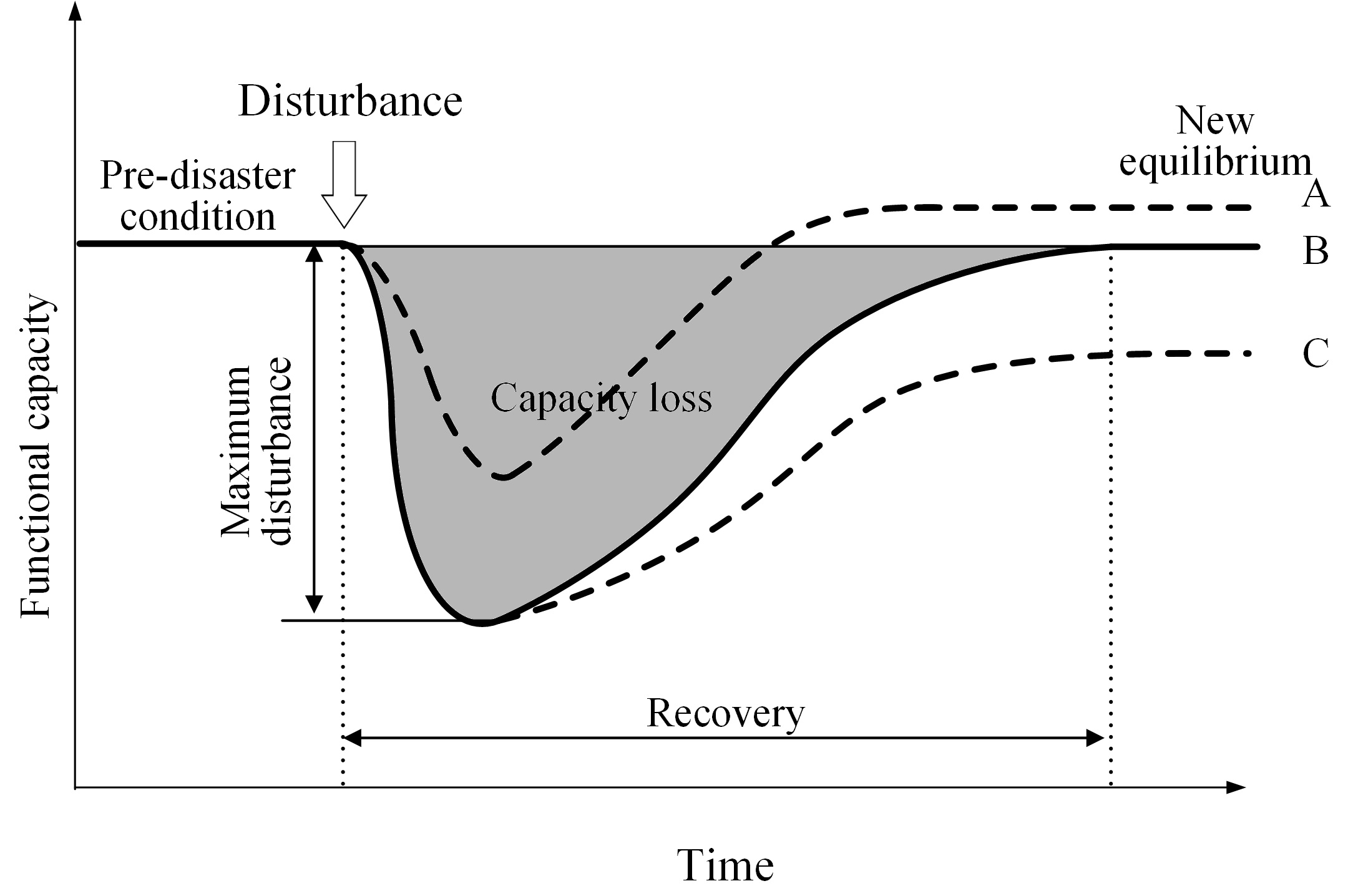
Quantitative Modeling of Disaster Resilience
We utilize various types of geospatial data (e.g. remote sensing images, social media data and mobility data) and machine learning techniques to detect human dynamics in disasters at multiple scales. We develop quantitative models to assess disaster resilience and explain socio-economic factors that affect the resilience. A suite of modeling frameworks and tools are developed to assess community and infrastructure resilience in various disasters and at multiple spatio-temporal scales.
Relevant Publications
- Qiang, Y.,
Huang, Q., Xu, J., (2020) “Observing Disaster Resilience from Space: Using Nighttime
Lights to Model Economic Disturbance and Recovery Pattern in Natural Disaster”, Sustainable Cities and
Society, vol.57. [pdf]
- Qiang, Y., Xu. J., (2020) “Empirical assessment of road network resilience in natural hazards using crowdsourced traffic data”, International Journal of Geographical Information Science. vol: 12(34) pp.2434-2450. [pdf]
- Cai, H., Lam, N., Zou, L., Qiang, Y., Li, K., (2015) “Assessing
Community Resilience to Coastal Hazards in the Lower Mississippi River Basin”, Water. vol: 8(1). DOI:10.3390/w8020046 [access]
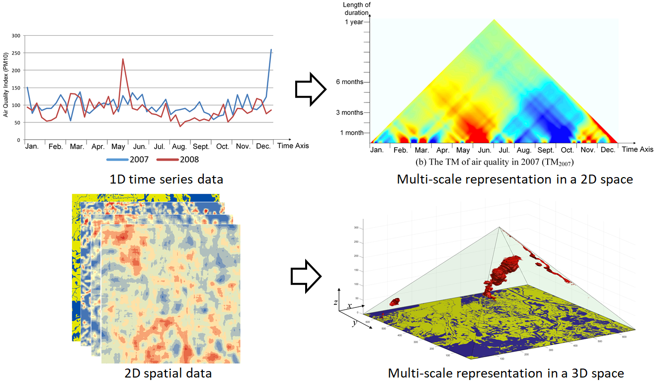
Multi-Scale Spatio-Temporal Modeling
This research aims to address the long-standing challenges of multi-scale spatio-temporal analysis in GIS. This research subverts the traditional views of space (flat layers) and time (linear intervals) and create new data models and analytical tools based on the Triangle and Pyramid Model. Our goal is developing a unified modeling framework to measures patterns and relationships across spatial and temporal scales.
Learn more about the NSF-funded
CroScalar project.
Relevant Publications
- Qiang, Y., Buttenfield, B. P., Joseph, M. B., (2020) “How to Measure Distance on a Digital Terrain Surface and Why it Matters in Geographical Analysis”, Geographical Analysis. vol.53(3),
pp. 588-622. [pdf]
- Qiang, Y. and Van de Weghe, N. (2019) “Re-Arranging Space, Time and Scales in GIS: Alternative Models for Multi-Scale Spatio-Temporal Modeling and Analyses”, ISPRS International Journal of Geo-Information. vol: 8(2). DOI:10.3390/ijgi8020072 [access]
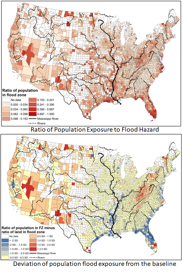
Environmental Justice in Hazards
We utilize GIS and spatial analysis to study environmental injustice and social disparities related to disaster risk and urban planning. We conducted national assessments of population and infrastructure exposure to flooding hazards. We also applied GIS to evaluate the inequalities in the exposure to scenic landscapes. The goal of these studies are to detect population groups that are disproportionally exposed to flooding hazards. Our studies revealled the systematical inequalities and injustice associated with hazard exposure and share of environmental resources.
Relevant Publication
- Qiang, Y. (2019) “Disparities of Population Exposed to Flood Hazards in the United States”, Journal of Environmental Management. vol: 232 (15). DOI:10.1016/j.jenvman.2018.11.039 [pdf]
- Qiang, Y. (2019) “Flood Exposure of Critical Infrastructure in the United States”, International Journal of Disaster Risk Reduction. vol: 39, DOI:10.1016/j.ijdrr.2019.101240 [pdf]
- Qiang, Y., Lam, N., Zou, L. and Cai, H., (2017) 'Changes in Exposure to Flood Hazards in the United States', Annals of the American Association of Geographers, vol. 107, no. 6. [pdf]
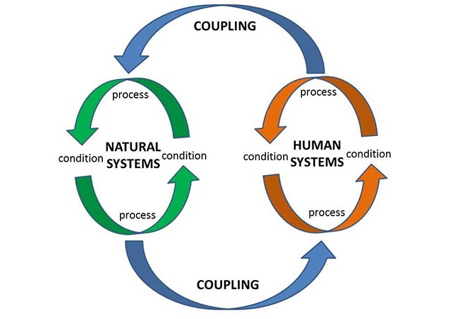
Multi-Scale Spatio-Temporal Modeling
Interactions between the systems are typically dynamic, non-linear and nested. Understanding the dynamics of coupled natural and human (CNH) systems is critical for evaluating resilience and sustainability of social and eco-systems. To this end, we apply artificial intelligence (AI) and geosimulation to model dynamic interactions in CNH systems. Such models have been used to predict land cover change, population movement and eco-system degradation in scenarios of natural disasters and climate change.
Relevant Publications
- Qiang,
Y. and Lam, N., (2016) “The Impact of Hurricane Katrina on Urban Growth
in Louisiana: An Analysis Using Data Mining and Simulation Approaches”, International Journal of Geographical
Information Science. vol:30(9). [pdf]
- Qiang,
Y. and Lam, N., (2015) “Modeling Land Use and Land Cover Changes in a
Vulnerable Coastal Region Using Artificial Neural Networks and Cellular
Automata”, Environmental Monitoring and
Assessment. vol:187(3).
DOI:10.1007/s10661-015-4298-8 [pdf]
- Lam, NSN., Xu, Y.J.,
Liu, K., Dismukes, D.E., Reams, M., Pace, R.K., Qiang, Y., Narra, S., Li, K., Bianchette, T.A., Cai, H., Zou, L.,
Mihunov, V. (2018).
“Understanding the Mississippi River Delta as a Coupled Natural-Human System:
Research Methods, Challenges, and Prospects.” Water. vol: 10(8). [access].